
CURLEWs
You could once hear the Curlew in every county of Ireland.
But now the Curlew could go extinct in Ireland within 5-10 years.
Today, we can still hear the Curlew in Ardee Bog.
But for how much longer?
This video by Anja Murray and the Eco Eye team explains how dire the situation is. One quarter of all wildlife in Ireland is threatened with extinction.
Click here for information on Curlews from BirdWatch Ireland.
Click here for information on Curlews from the Curlew Recovery Partnership.
Click here for RESOURCES and FACTSHEETS from the Curlew Recovery Partnership.
Click here for a Curlew Factsheet from the IPCC, Irish Peatland Conservation Council.
CURLEWS IN ARDEE BOG

Map of Curlew feeding sites (and possible nesting sites) in and around Ardee Bog.
This map of Ardee Bog and the surrounding bufferzone habitat shows eleven key sites where Curlews feed and possibly nest.
The area was surveyed and mapped by the County Louth Ranger with a FAB member over the course of a few days in June 2019.
Four of these sites are in the direct path of the proposed N52 Ardee bypass, indicated by the orange line.
Click here for the history and time-line for the Curlew survey in Ardee Bog by the County Louth Ranger in May / June 2019.
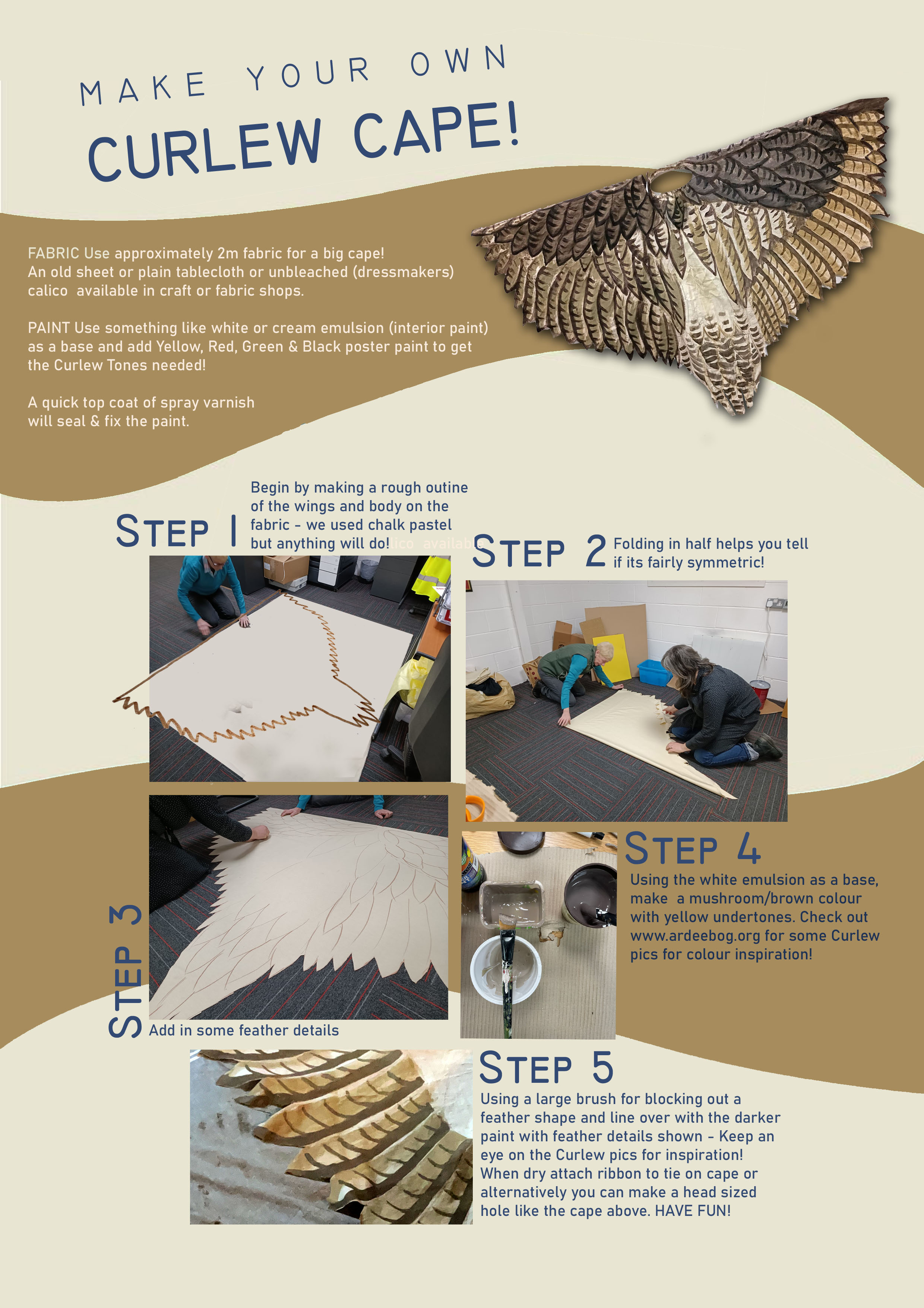
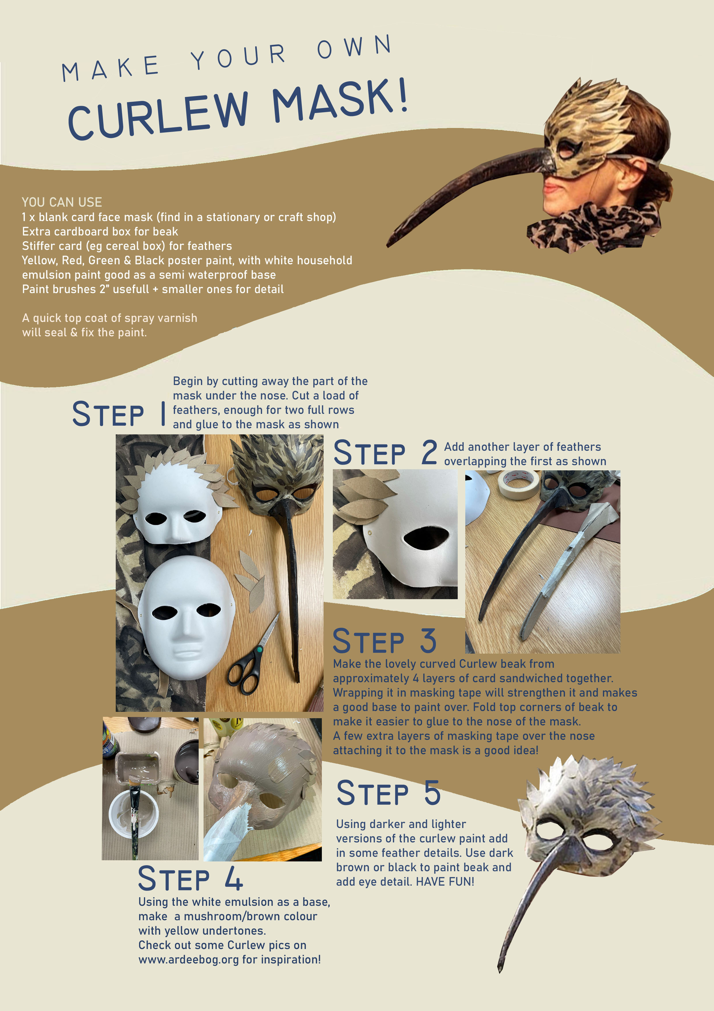
MAKE YOUR OWN CURLEW CAPE & MASK
Our FAB member Rachel Murphy created a simple guide on how to make your own Curlew costume. Why not make your own!
Click here to download instructions on how to make a CURLEW CAPE
Click here to download instructions on how to make a CURLEW MASK

CURLEW SURVEY IN ARDEE BOG
WE RECORD EVERY SIGHTING & SOUNDING OF CURLEWS IN AND AROUND ARDEE BOG.
BREEDING SEASON (March - MAY) IS PARTICULARLY IMPORTANT. IE: RIGHT NOW!
JOIN OUR WHATSAPP GROUP TO HELP!
GROUND NESTING BIRDS
It's nesting season! From March-July we need to be extra careful to protect nests. Curlews nest on the ground and so are particularly vulnerable to disturbance from walkers, dogs, and farm equipment. Let's work together to make sure curlews have a successful nesting season by walking carefully and keeping dogs on leads in nesting areas.
REPORT A RINGED CURLEW
If you spot a ringed curlew please send details to sightings@waderstudygroup.org and cc info@curlewcalls.org
Include as much detail as possible:
Location
Date
Time of day
Numbers/ letters on the ring (if possible)
Colours of bands (as if looking at bird front on e.g. left leg, red over blue, right leg white over green)
Photo (if possible)
WE MUST SAVE THE CURLEWS IN ARDEE BOG
We have evidence of Curlews feeding - and possibly nesting - in the route of the proposed N52 Ardee bypass.
Curlews are on the brink of extinction in Ireland. They are red-listed and protected by National and EU directives.
We are monitoring the Curlews and undertaking a formal survey now in Spring 2022.

Fencing for the N52 Ardee Bypass (pictured above) was illegally installed in October/November 2019 after the Oireachtas ordered all work to stop while the road design was reviewed. Curlew habitat was destroyed by the illegal roadworks. The bypass must be stopped.
Fields surrounding Ardee Bog are part of the proposed Natural Heritage Area (pNHA) of Ardee Bog. The aerial video above shows how they regularly flood. They are home to Curlews, Snipe, Swans, Frogs, and more creatures.
The video also gives you a good view of the illegal fencing.

This aerial video footage shows the exact route of the proposed N52 Ardee bypass through Ardee Bog and its surrounding Bufferzone Habitat, which now suffers from severe flooding. Filmed on March 19th, 2019 before the illegal fencing was installed.
Both videos were filmed by FAB member Seán Walsh, a certified drone operator.
proposed n52 ardee bypass
The proposed N52 Ardee bypass is not fit for purpose. It is flawed in many ways, but one of the most egregious aspects is that it destroys precious Curlew habitat.
The map below is taken from materials presented by the N52 Ardee Bypass Public Consultation #2 (October-November 2020).
The purple line indicates the proposed route of the N52 Ardee Bypass (with revised plans for junctions and a cul-de-sac on the Mullenstown road).
Friends of Ardee Bog added a hand-drawn blue line to indicate the pNHA of Ardee Bog.

The purple line (bypass) clearly goes through the pNHA of Ardee Bog (blue line). This is criminal!
The map below indicates Ardee Bog’s Flood Zone, showing where the proposed road would be swamped with feet of water a few times a year.

Again: The purple line indicates the proposed route of the N52 Ardee Bypass. Blue line is pNHA of Ardee Bog and light blue line is the designated Flood Zone; Curlew habitat. The proposed road would cut through the pNHA of Ardee Bog and surrounding Flood Zone which is Curlew habitat.
An Environmental Impact Assessment was never carried out.
Ireland declared a Climate Emergency in 2019. Yet the government and Louth County Council propose building a poorly designed road through a Flood Zone, a raised bog that took 10,000 years to form, habitat and home to red-listed Curlews which are endangered and on the brink of extinction in Ireland. It boggles the mind.
Louth County Council has already illegally removed c. 4km of hedgerows and mature trees to install fencing along the proposed route. This work destroyed Curlew habitat.

Recent maps of the N52 Ardee bypass provided by Transport Infrastructure Ireland and Louth County Council fail to show the pNHA of Ardee Bog. They magically made the bog disappear! The image on the left shows the pNHA in red (hand drawn by us).
CLICK HERE TO SIGN OUR PETITION
We believe our work shows why the N52 Ardee Bypass can not go through the pNHA of Ardee Bog
Click here for more info
IPCC ACTION PLAN
The Irish Peatland Conservation Council has created an Action Plan 2020: Ireland’s Peatland Conservation Action Plan 2020 – halting the loss of peatland biodiversity during 2009. The aim of this plan is to develop a national strategy for the conservation and management of all peatland types in Ireland. The findings of the plan are as follows:
269,267ha of peatlands are of conservation interest in Ireland. This represents 23% of the original peatland area in the country.
There are 736 peatland sites of conservation value in the Republic of Ireland and 138 peatland sites of conservation value in Northern Ireland.
129 actions are needed to conserve our peatlands and return degraded and threatened peatlands to favourable conservation status.
The Irish Government have not yet completed the formal designation of peatlands of conservation value as Natural Heritage Areas and Special Areas of Conservation.
395 peatlands of conservation importance in Ireland have no formal conservation designation under national or international legislation.
The key human activities leading to peatland habitat loss and degradation include turf extraction, afforestation, agricultural reclamation, overgrazing, the construction of wind farms on peatlands, tourism, trampling, dumping and burning. Drainage is associated with most of these activities.
40% of our peatland resources have been lost to turbary or turf cutting for domestic use, which represents the single greatest loss of habitat in Ireland.
Every peatland of conservation importance listed in the plan is affected by turf cutting.
Drainage and degradation of peatlands makes them to susceptible to colonization by invasive species including Rhododendron ponticum and Sarracenia purpurea.
Drainage of peatlands is contributing to Ireland’s greenhouse gas emissions. A high water table must be restored to damaged peatlands if their greenhouse gas storage functions are to operate.
Pollution of ground water may be leading to increased eutrophication of fen habitats.
The marsh fritillary butterfly, red grouse, common frog, marsh saxifrage and whorl snails are considered to be indicator species of peatland health.
Peatland management plans have been prepared for only 6% of the sites of conservation value. Peatland restoration work has only been undertaken on 9% of the peatlands of conservation importance.